Some Things You Should Know Before You Ever Wet a Line
Before we talk about trout, before we talk about tactics, before we get into flows and hatches and fly patterns, I want you to understand something fundamental about this river and where it comes from. The Chattahoochee tailwater does not exist in isolation. It is the downstream consequence of one of the most consequential engineering projects in the history of the American South. To truly understand this river, you have to start forty miles north of Atlanta at a massive earthen structure spanning the Chattahoochee River in Forsyth County, Georgia. You have to start at Buford Dam.
Everything that makes this tailwater what it is — the cold water, the trout, the year-round fishability, the very character of the river itself — flows directly from the decisions made in Washington and Atlanta in the 1940s and the construction that followed through the 1950s. Once you understand what Buford Dam is and what it does, the river below it starts to make a lot more sense.
The Decision to Build
Atlanta in the years immediately following World War II was growing fast. The city and the surrounding region were expanding in ways that were straining every resource, and chief among those resources was water. The Chattahoochee River was the primary source, but without a storage reservoir to buffer against drought, the supply was unreliable. Leaders in Atlanta understood that the city’s future growth depended on solving that problem.
Congress authorized the construction of Buford Dam in 1946. Ground was broken on March 1, 1950, in a ceremony that drew nearly five thousand spectators, including Atlanta Mayor William B. Hartsfield and Governor Eugene Talmadge. The event had the feel of something historic, because it was. The construction that followed was a massive, seven-year undertaking that employed thousands of workers and reshaped the landscape of north Georgia in ways that are still being felt today.
The human cost of the project is something that gets glossed over in most accounts but deserves to be acknowledged. The creation of Lake Lanier required flooding over fifty thousand acres of farmland and forest. More than two hundred fifty families were displaced from their homes. Fifteen businesses were shut down and relocated. Twenty cemeteries had to be moved, their remains carefully disinterred and reburied on higher ground. Entire communities that had existed for generations — including the historic settlement of Oscarville at the confluence of the Chattahoochee and Chestatee Rivers — were swallowed by the rising water. The land at the bottom of Lake Lanier was home to real people with real lives, and they gave up that land so that millions of others could have a reliable water supply and eventually a world-class recreational resource. That sacrifice deserves to be remembered.
The gates of Buford Dam’s intake structure were closed on February 1, 1956, and Lake Lanier began to fill. It took more than two years, slowed by drought and deliberate pauses by the Corps of Engineers to protect ongoing worksites. The lake finally reached its intended full-pool elevation on August 1, 1958. Buford Dam was officially dedicated on October 9, 1957, in a ceremony officiated by U.S. Senator Richard B. Russell, Georgia Governor Marvin Griffin, and Mayor Hartsfield. In June of 1958, the lake opened to the public for recreation. The region has never been the same.
What Buford Dam Actually Does
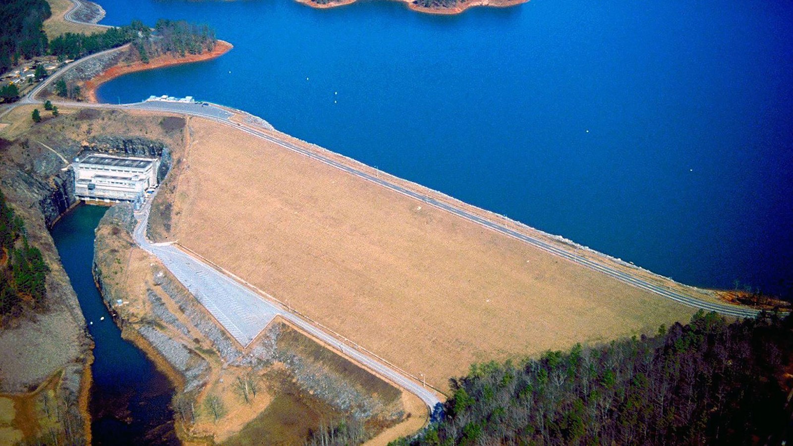
It helps to understand the physical structure and its functions. Buford Dam is a combination earth and concrete structure supplemented by three saddle dikes that hold the lake in place along its boundaries. At the dam itself, Lake Lanier is more than two hundred feet deep. The powerhouse contains three generators — one small unit that runs continuously and two sixty-megawatt generators that operate twice daily during peak electricity demand. The facility produces approximately 250 million kilowatt-hours of hydroelectric power annually, which is marketed and distributed to the metro Atlanta area. Control of the dam’s generators is handled remotely from Carters Dam near Ellijay via microwave signal, which means a facility in the mountains controls what happens to the water right here in our backyard.
There is also a thirteen-foot diameter sluice that allows water to bypass the turbines entirely when needed for flood control or other management purposes. When water is released through the turbines, sirens sound along the river to alert anyone downstream — a safety protocol that every angler and paddler on this river needs to be aware of.
The dam serves four primary purposes: water supply, flood control, hydroelectric power generation, and recreation. All four of those functions directly affect how this river behaves and why it matters to the entire region.
The Water Supply Story
Lake Lanier today provides drinking water to approximately five million people. Read that number again. Five million people. The reservoir holds roughly thirty-eight thousand surface acres of water with nearly seven hundred miles of shoreline, and it feeds water treatment plants serving communities from Gainesville and Forsyth County all the way down through Gwinnett, Hall, Dawson, and the northern reaches of metro Atlanta. On an average day, close to five hundred million gallons of water are drawn from Lake Lanier to supply the drinking water needs of this entire region.
When Atlanta Mayor Hartsfield was lobbying Congress in the 1950s for additional funding to complete the dam, he kept returning to one central argument: Atlanta’s future depended on a reliable water supply during droughts. He was right in ways that even he probably could not fully anticipate. The metro Atlanta region grew from a mid-sized southern city to one of the largest and fastest-growing metropolitan areas in the entire country during the decades following the dam’s construction. Without Lake Lanier, that growth trajectory would have been impossible.
The significance of this was driven home sharply in 2007, when a severe multi-year drought pushed Lake Lanier to record low levels. The water surface dropped nearly twenty feet below full pool, and officials were genuinely discussing worst-case scenarios for the region’s water supply. The crisis eventually passed, but it gave every resident of north Georgia a clear reminder of how completely this region depends on that reservoir sitting behind Buford Dam.
Flood Control on the Chattahoochee
Before Buford Dam existed, the Chattahoochee River in the piedmont was subject to the kind of catastrophic flooding that periodically devastated communities along its banks. The river would respond to heavy rainfall events in the north Georgia mountains by rising dramatically and violently, with very little time for communities downstream to prepare.
Since the construction of the dam, only three major flooding events have occurred on the downstream section of the river. The dam absorbs and manages the flood pulse by capturing storm runoff in the reservoir and releasing water in a controlled manner, dramatically reducing the peak flows that used to roll through communities and farmland without warning. The most severe post-dam flood event came in 2009 in the wake of a two-year drought that had depleted the reservoir’s capacity to buffer incoming storm water, but even that event was less severe than what the uncontrolled pre-dam river would have produced.
For the communities along the Chattahoochee River corridor from Forsyth County through Gwinnett, Fulton, and Cobb Counties, Buford Dam is not an abstract infrastructure project. It is the reason their homes, businesses, and roads have not been repeatedly destroyed by a free-flowing piedmont river doing what free-flowing piedmont rivers do.
The Cold Water Release and Why It Matters
This is where the story shifts from infrastructure and civil engineering to something I care about much more personally — what that dam does for the river and the fish.
The powerhouse at Buford Dam draws its water from the bottom of Lake Lanier. Not from the surface, where a Georgia summer would warm it to temperatures hostile to trout, but from the deep cold bottom of a reservoir that is more than two hundred feet deep at its deepest point. That cold, oxygen-rich water flows out of the dam year-round, typically in the range of fifty to fifty-five degrees Fahrenheit even in the peak of summer when air temperatures outside are pushing into the upper nineties.
That cold release is the entire reason this tailwater exists as a trout fishery. There is simply no other explanation for why rainbow and brown trout can survive thirty miles from downtown Atlanta in the middle of summer. It is not natural. It is entirely the product of engineering. But it is one of the most remarkable unintended consequences of a major infrastructure project that I can think of anywhere in the country.
The Buford Trout Hatchery was established on the riverbank immediately below the dam specifically to take advantage of this cold water. The hatchery pumps river water directly from below the dam for its production raceways and returns it to the river when it’s done. The dam created the cold water. The cold water enabled the hatchery. The hatchery fuels the stocking program. The stocking program produces the fishery. It is a chain of cause and effect that started when workers blasted through granite in Forsyth County in the early 1950s.
The Water Wars
No discussion of Lake Lanier and Buford Dam is complete without at least acknowledging the ongoing battle over its water. Since the 1990s, Georgia, Alabama, and Florida have been in a sustained legal and political conflict over how the water in Lake Lanier can be used and how much must be released downstream to satisfy the needs of communities and ecosystems in Alabama and Florida.
The Apalachicola River in Florida, which is the downstream extension of the Chattahoochee, supports a unique estuary ecosystem including commercially valuable oyster beds that depend on freshwater flows from Georgia. Alabama communities along the Coosa and Tallapoosa watersheds have their own water needs that intersect with Corps of Engineers management decisions. Federal law requires that when a river flows between multiple states, each state has a right to a share of the water, and the Endangered Species Act adds further requirements to protect threatened and endangered species downstream.
The result has been decades of litigation, negotiation, and political maneuvering that periodically affects how the Corps of Engineers manages flows out of Buford Dam. For the angler or paddler on the Chattahoochee tailwater, the practical effect of this ongoing dispute is that dam releases are not managed solely for local recreational interests. They are the product of a complex multi-state negotiation that extends all the way to the Gulf Coast of Florida. When flows on the tailwater behave unexpectedly, the water wars are often part of the explanation.
The National Recreation Area
The other thing that Buford Dam and Lake Lanier made possible, somewhat indirectly, is the Chattahoochee River National Recreation Area. Established on August 15, 1978, by President Jimmy Carter — himself a Georgia native who understood this river’s importance — the CRNRA preserves a series of sites along a forty-eight-mile stretch of the Chattahoochee River from Buford Dam to northwest Atlanta. The park encompasses fifteen distinct units, more than six thousand acres of protected land, and over fifty miles of trails.
The park was created specifically to protect the river corridor from the development pressure that was consuming north Georgia’s landscape during the rapid suburban expansion of the 1970s. Without federal protection, the riverbanks through this entire stretch would likely have been developed, blocking access and degrading the habitat that makes this river valuable. Carter’s decision to establish the CRNRA gave every person in metro Atlanta a protected stretch of wild riverfront that belongs to everyone. It is one of the best things a Georgia politician has ever done for the people of this state, and I say that as someone who has spent a significant portion of his life in and on that river.
The recreation area attracts more than three million visitors per year. For a national park unit that requires no long drive and no special equipment, those numbers reflect how deeply embedded this river has become in the daily recreational life of Atlanta.
Morgan Falls Dam
Fourteen miles downstream of Buford Dam sits a smaller but important structure that plays a direct role in tailwater management. Morgan Falls Dam, owned and operated by Georgia Power, was actually raised in 1957 specifically to help regulate the irregular flows coming out of the new Buford Dam. It functions as a re-regulation structure, smoothing out the pulse flows created when Buford’s generators cycle on and off for peak power demand. The pool behind Morgan Falls Dam creates flatwater conditions in a section of the river that would otherwise be dominated by the highly variable releases from above.
For paddlers, this pool is accessible and calm. For anglers, the area around Morgan Falls is productive and holds fish year-round. The dam also creates a distinct boundary in the stocking program, as the types and sizes of fish stocked above and below it differ significantly. Understanding Morgan Falls as a feature of the tailwater — not just Buford Dam — gives you a more complete picture of how this river is managed and why different sections fish differently.
The River Beyond Fishing — Recreation on the Chattahoochee Tailwater
I am first and foremost a fisherman, and this guidebook is written primarily for anglers. But I would be doing this river a disservice if I pretended that fishing is the only reason people come here. The Chattahoochee tailwater is one of the most diverse and accessible recreational resources in the entire Southeast, and the millions of people who use it for purposes other than fishing are part of what makes it worth protecting.
Paddling
Whether you’re in a kayak, a canoe, a stand-up paddleboard, or an inflatable tube, the Chattahoochee tailwater offers something for virtually every skill level and interest. The upper tailwater near Buford Dam and through the Medlock Bridge and Jones Bridge sections is characterized by clear, cold water moving over gravel bars and through rocky shoals. It is exceptional kayak fishing water and some of the most beautiful flatwater paddling you will find within an hour of a major American city.
As the river moves south toward Roswell and into the CRNRA proper, it softens into a more accessible corridor with Class I and Class II rapids that families and casual paddlers can navigate comfortably with rented gear. Multiple outfitters operate along this section and have for decades, providing kayaks, canoes, tubes, and paddleboards to anyone who wants to get on the water without owning their own equipment.
The most famous paddling tradition on this river is what locals simply call shooting the ‘hooch — loading up tubes and coolers and floating from Powers Island or one of the other upper access points down through the lazy bends of the lower tailwater toward Paces Mill. On a hot summer weekend, the number of people on this river floating tubes is genuinely spectacular. It is a deeply embedded Atlanta tradition, and the river handles it in stride.
In 2012, the CRNRA was designated as the Chattahoochee River Water Trail, making it the first river in the country to receive that designation from the National Park Service. That recognition reflects both the quality of the paddling experience and the infrastructure of access points, portages, and put-in and take-out locations that have been developed along its length.
Hiking and Trail Running
The CRNRA’s fifteen park units include more than fifty miles of trails ranging from easy, paved riverside walks to genuinely demanding ridge-top hikes with elevation changes that will remind you that you’re not as far from the mountains as Atlanta’s skyline might suggest.
The East Palisades Trail near Buckhead is one of the most popular and dramatic hikes in the entire metro area. It winds through bamboo forests and down to rocky river bluffs, passes historic ruins, and offers overlook views that stop most people in their tracks the first time they see them. The West Palisades section is more accessible but no less scenic. The Cochran Shoals unit near Powers Island includes some of the most heavily used trail mileage in the entire National Park System on a per-acre basis — a remarkable distinction for a park embedded in a major metropolitan area.
The Vickery Creek unit in Roswell is another standout. The trail winds along the creek past the ruins of an old wool mill that was burned by Union troops during the Civil War, crosses a historic dam site, and drops down to the Chattahoochee confluence in a setting that feels genuinely remote despite being five minutes from downtown Roswell. I have brought people to that trail who had no idea it existed, and their reaction is always the same. They cannot believe they are still in metro Atlanta.
Wildlife Watching
The Chattahoochee corridor supports a remarkable diversity of wildlife for an urban river. More than 240 bird species have been documented within the CRNRA, including nesting bald eagles, ospreys, herons, kingfishers, wood ducks, and during migration, a parade of warblers, vireos, and other songbirds that use the river corridor as a flyway. White-tailed deer are common enough to be almost unremarkable, and if you spend any time on this river you will also encounter beaver, river otter, red fox, mink, and the occasional coyote.
From a kayak at water level in the early morning, the wildlife experience on this river is genuinely exceptional. I have paddled through flocks of wood ducks exploding off the water in the morning mist, watched osprey fold their wings and hit the surface thirty feet in front of me, and drifted within arm’s length of great blue herons standing motionless in the shallows. The river corridor is a wildlife refuge running through the middle of one of the largest and fastest-growing cities in the country, and the animals use it accordingly.
The Chattahoochee Nature Center, located directly on the river in Roswell, is worth mentioning as well. It sits on 127 acres of forest, wetlands, and river habitat and offers trails, exhibits, and educational programming for all ages. For families with children who are not yet old enough to fish or paddle, it is one of the best introductions to the natural world this river has to offer.
Mountain Biking
The trail systems along the CRNRA are increasingly popular with mountain bikers, and several units offer terrain that legitimate trail riders find genuinely interesting. The Cochran Shoals area and the Sope Creek trail system near Marietta are particularly well-regarded for mixed hiking and biking terrain that moves through hardwood forest, crosses creek drainages, and eventually delivers you to river overlooks worth every pedal stroke it took to get there.
Picnicking, Swimming, and Just Being Outside
I do not want to over-complicate this. One of the great things about the Chattahoochee River National Recreation Area is that you do not need a plan or a purpose to benefit from it. Picnic areas are scattered throughout all fifteen units. Gravel bars and sandy banks invite you to sit down, take off your shoes, and put your feet in the water. On a summer afternoon when Atlanta is baking, the river corridor is reliably cooler than the surrounding city by several degrees, and the sound of moving water does something to your nervous system that no amount of indoor air conditioning can replicate.
This river is Atlanta’s front porch, its backyard, and its wild edge all at once. Three million people a year come here not because they have a specific recreational objective but because the river exists and it is close and it is free and it is one of the few places in this city where you can stand still and hear nothing made by human hands.
A Resource Worth Understanding and Protecting
Lake Lanier holds roughly 1.1 trillion gallons of water when it is at full pool. Buford Dam controls every drop that flows through the tailwater below it. The decisions made by the Corps of Engineers about how to manage that water affect the drinking supply of five million people, the flood safety of communities along the river’s length, the electricity grid of the metro Atlanta region, and the health of a trout fishery and a recreational corridor that millions of people depend on for their quality of life.
That is a lot of weight for one dam to carry, and it is why the Chattahoochee River is more than just a fishing destination. It is the circulatory system of north Georgia. Everything downstream — every community, every ecosystem, every angler standing knee-deep in the current at six in the morning watching the mist come off the water — exists in relationship to that structure on the Forsyth County line.
I want you to fish this river well. I want you to catch fish and enjoy every minute of it. But I also want you to understand what you are standing in when you wade into the Chattahoochee below Buford Dam. You are standing in the product of seventy years of management, sacrifice, engineering, and conservation. You are standing in something that matters far beyond your day on the water.
Treat it accordingly.